I'll take your word for it.
But again, I don't think he's talking about increased runoff. I believe he's just talking about greater than normal rainfall and severe weather. It's been bad for the past couple of months, really bad.
And I don't know about his part of the country, but it would take decades of excessive rainfall in my area, to raise the groundwater levels to the point where they'd impact flash flood storage capability.
Although lake levels in CenTex are up to "full" for the most part, the aquifers are still exceedingly dry. We've severely overtaxed our water supply in Central Texas. One of the reasons I'll likely be moving once the kids graduate high school. This area really can't tolerate the prolonged growth, it WILL run out of water.
In general, I was indeed referring to the 6 weeks of nearly daily rainfall, some of it quite heavy. To the point that I believe we have already received our average annual rainfall.
But the lakes
did fill, the dams had to release water at record rates, in some cases the water overflowed the dams, the rivers were swollen and overflowed their banks in many places, and in other places levees kept the low-lying land from flooding. The levees along the Arkansas River just just west of the Tulsa city limits had been built in the '40s, and not updated or upgraded since. There had been dire warnings that they would not hold if there were a long period of heavy rainfall. In some cases, the water overflowed them, but, to about the 99 and 44/100ths% level, they did hold.
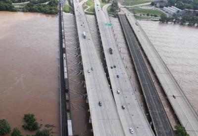
Here's a pic of a series of bridges southwest of downtown Tulsa (looking northeast). From l. to r., the are the BNSC RR bridge, two bridges for I-244, the now inactive Cyrus Avery Rte 66 bridge, and the Southwest Blvd. bridge. The Arkansas River is nearly twice its normal width, and probably 15 feet higher than normal.
50+ highway miles downstream, where the Neosho River (maybe 15 miles downstream of the Fort Gibson Dam) flows into the Arkansas near the small city of Fort Gibson, there was this.